Discover Milwaukee’s Local History
Grand Old Leaf
Last week I talked about winter learning and how important it is to embrace the outdoors throughout all the seasons I briefly discussed benefits and connections we can easily make to our learning curriculums when spending time outdoors. Milwaukee is a great city for free or inexpensive exploration in the larger world. Learning outside adds a dimension of enrichment that can’t be taught within the walls of the classroom.
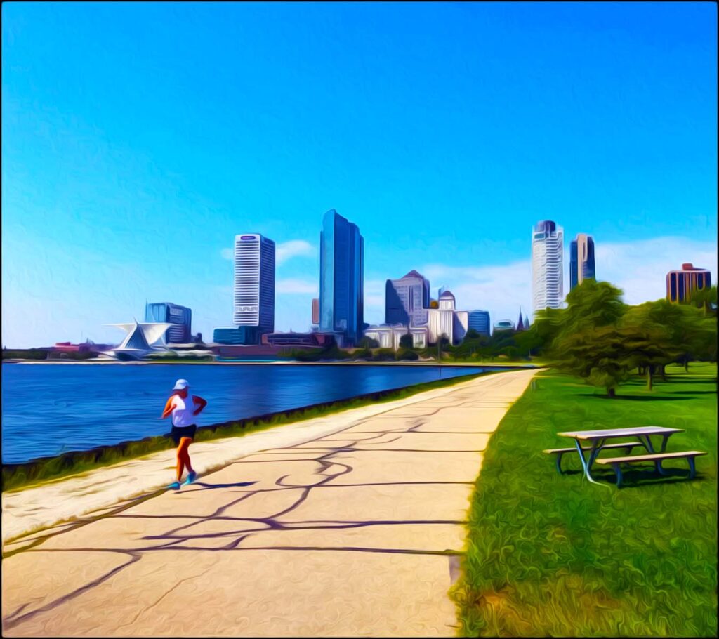
The connection easiest made to winter learning is to our history. Specifically, local history. Milwaukee’s a great place for a bike ride in the park! A simple place to start is by choosing from the over 150 parks comprising our county’s emerald necklace to learn about. The emerald necklace is the term used to describe our city’s extensive public park and parkway system.
Milwaukee had a Youth Hostelling Movement
Recently, I’ve taken up a renewed interest in local Milwaukee history. I’ve also made some new, interesting discoveries. One finding especially noteworthy is the interconnectedness of three Milwaukee public works: The Milwaukee County parks and parkways, Milwaukee’s freeway system and the county’s Oak Leaf Trail. Similar to the grand “Ring of Parks,” the evolution of the Grand Old Leaf was strongly influenced by German culture and depended heavily on the fate of the county’s parks and freeways.
Before the 1996 revitalization of the Oak Leaf Trail, the path was known by other names. In conjunction with Milwaukee’s public park system, “The Grand Loop” was one of its earliest incarnations. The idea for a long-distance bike trail first came when youth hostelling groups began forming around the city.
Often appealing to the “he’s spending the summer backpacking through Europe” demographic, a hostel might be compared to splitting rooms at a low-budget motel. Accommodations are kept to a minimum through the sharing of traveler resources. Common features of hostels around the world include shared sleeping spaces such as in a dorm, local tourist information, meals and events, along with a common area for travelers to gather.
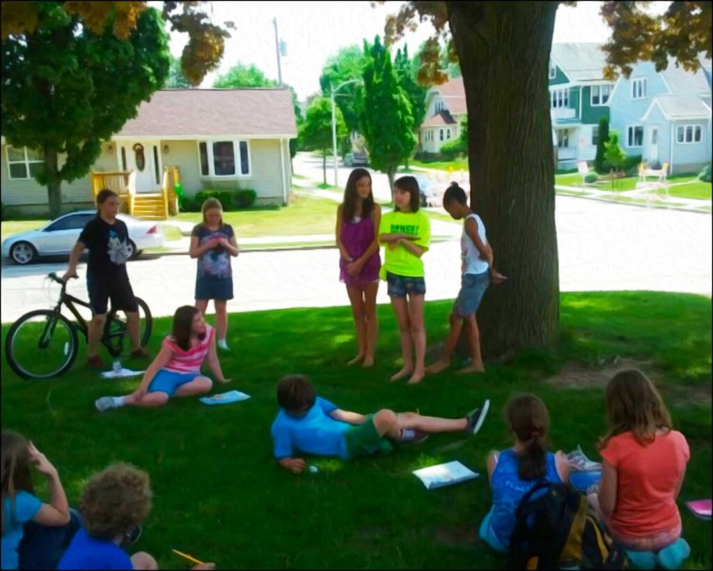
a bicycle safety course at Fernwood Montessori.

One of the effects of the decade long Great Depression was the reinvigoration of the sport of cycling. As more Americans turned to bicycles as an alternative to higher-cost transportation, city streets remained congested with automobiles, trucks and trolleys. Consequently, devoted cyclists feared a short-lived cycling revival. They were in search of safer routes other than sidewalks or through dangerous city streets for bike travel.
Back in 1936, Milwaukee’s director of athletics Harold “Zip” Morgan was devoted to cycling. Morgan led rides, some having dozens of participants, along paths and through the southeastern Wisconsin countryside. Those interested in long trips along country trails were also interested in low-cost lodging options along the way. Overtime, Zip and a group of fellow bikers imagined the creation of a formalized public bike line. In 1939, Zip was the first to lay out a trail stretching over 64 miles.
A long-time European tradition, the Milwaukee hostel movement was an import from Germany. The hostel movement, both locally and across the United States, was part of a larger effort to return to the simplicity of the outdoors. Efforts were made, but in the end, a Wauwatosa farmhouse located far out on North Avenue was the only hostel established in the area for the trail.
While Zip advocated for long-range hostelling routes, his biking companion Same Snead dreamed of a ’round-the-city loop’ for his bicycle group. Snead, district commissioner for the Boy Scouts of America, charted a route closely following along the lines of the planned grand “Ring of Parks” around the outer edges of the city. The group also proposed linking Milwaukee’s Grand Loop to Sheboygan County, with hostels located at 15-mile intervals. Sneed’s path would eventually develop into the Oak Leaf Trail.
What is A Grand Old Leaf?
The city first recognized Snead’s county trail as the Grand Old Leaf in 1965. By 1967, 4.5 miles of the trail was paved within Milwaukee’s Lake Park, paid for by a $35,000 federal grant. Lake Park’s original trail was specifically commissioned as a bike trail, attracting cycle enthusiasts around the country.
The National Bicycle Institute believed the trail might make Milwaukee “the bicycle hub of the United States.” For these reasons, the county designated Lake Park’s paved path as a bike trail for the first time in 1974. The earliest of its kind, the trail allowed for off-road routes through scenic county parks. It also finally linked bikers directly to “Cycle City’s” Downtown.
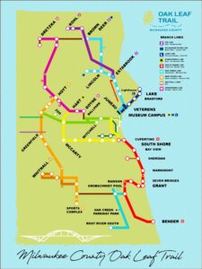
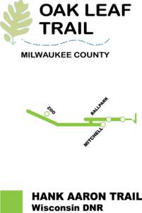
Today’s map of Milwaukee’s Oak Leaf Trail.
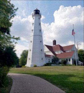
Lake Park’s North Point Lighthouse.
At the same time, the city had no direct way for cars or bicycles to travel safely from the Northside to the Southside of Milwaukee’s harbor. A lakefront freeway was officially added to the freeway planning maps in 1963. The idea was to build a high-rise bridge connecting to the southerly Jones Island peninsula. The lakefront route was proposed to reach as far south as Bay Street in Bay View.
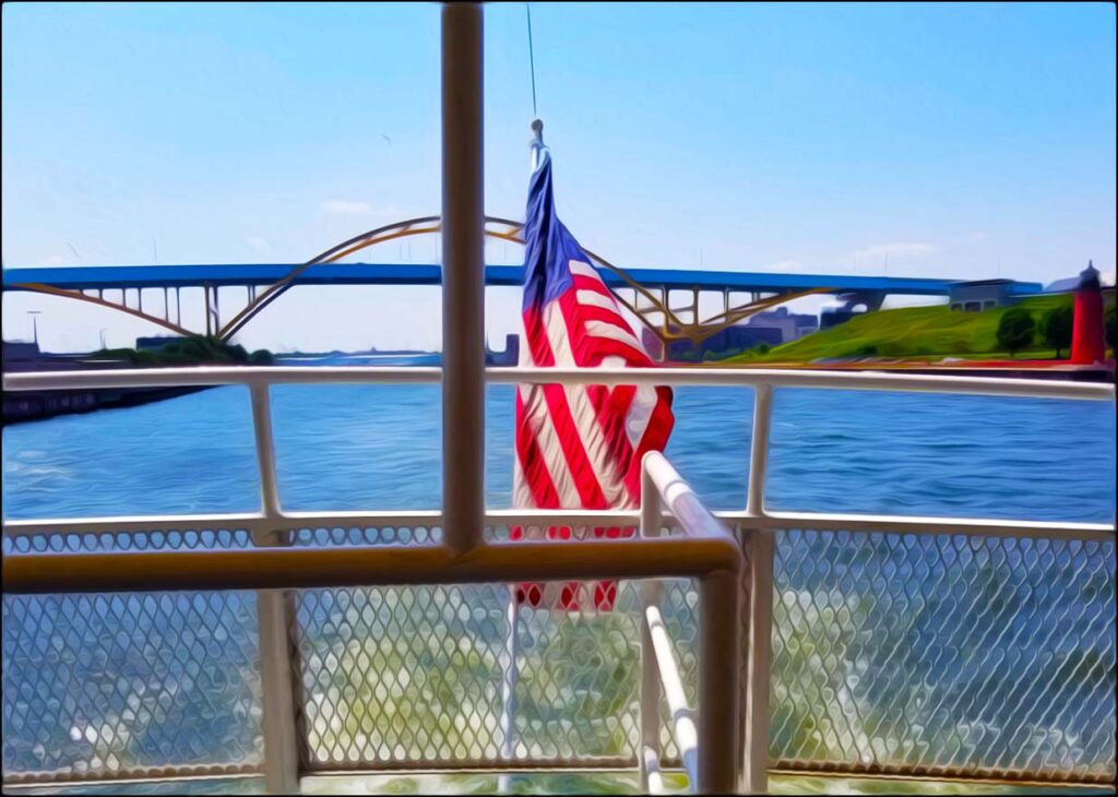
The main span of the Hoan Bridge was completed in 1975 but, due to local resistance groups, remained unused for two more years. It was during this time the bridge was nicknamed the “Bridge to Nowhere.”
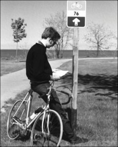
Image courtesy of
the Milwaukee County Parks
The year of 1976 was monumental for the country and for Milwaukee’s bicycle trail. To commemorate the bicentennial and in hopes to rustle up more support and funding, the city named the bike route the Milwaukee 76 Bicentennial Trail to honor the nation’s 200 year anniversary. Locals shortened the name to the Milwaukee 76 or simply, “The 76.”
Marked with red, white and blue signs, the trail was rumored to have measured a perfect 76 miles. There are no records, however, to support this fantastic claim. That same year, a Pedestrian and Bicycle Safety Plan was developed by the Division of Highway Safety Coordination.
In 1977, downtown’s East–West Freeway was finally attached to the Hoan Bridge on the north end, while the south end of the freeway was connected to Carferry Drive. The lakefront route opened to automobile traffic and to mixed reviews. Regrettably, there were neither pedestrian nor bicycle lanes included.
Back then, the official 76 Trail both started and ended on the Northside at Lake Park. The trail was substantially expanded and paved by 1978. A decade later, a 14-mile trail connecting South Shore Park was added to the Milwaukee County Grounds. This trail is now known as the Kinnickinnic River Parkway.
The Daniel Hoan Memorial Bridge
In the early 1990s, Milwaukee County received federal funds to create a bike connection between downtown Milwaukee and Bay View. Cycling enthusiasts began advocating for the addition of a bike lane along the Hoan Bridge. Unfortunately, citing issues such as safety concerns, local politicians hit the brakes on the idea. Other options were proposed, such as converting an old railroad route into a dedicated bicycle trail or including designated bike lanes on surface streets.
Proponents of the Hoan Bridge bicycle lane argued Milwaukee’s limited number of available surface streets (such as s. 1st St. just west of the inner harbor) were so heavily trafficked they would actually be far more dangerous for bikers. In addition to this, advocates pointed out other cities more heavily trafficked than the Hoan with bike lanes on bridges.
For example, a pedestrian lane was converted to a designated bicycle lane on the Golden Gate Bridge in 1970. San Francisco’s bridge includes an elevated lane marked for pedestrians on its east side while a designated lane for bicycles stands on its west side. More than 5,000 people safely bike across this bridge daily.
In 1998, the state Department of Transportation created an advisory committee to study all the suggested options. The committee concluded the Hoan Bridge bike lane would be safe for bicycle traffic.
A concrete barrier was proposed between the bike lane and the traffic lanes, making it safer than biking on some of the busier city surface streets. Unfortunately, the advisory committee’s recommendations were never implemented.
The Bike Federation was formed in 1995, a statewide bicycle-advocacy organization. The Bicycle Federation of Wisconsin offers free bicycle classes and other bicycle programs to schools around the city. My class participated in several different programs while at Fernwood Montessori.
After 15 years of the Lake Freeway abruptly ending at Jones’ Island’s Carferry Drive, a newly constructed half mile section of freeway opened in 1999 as part of the state trunk highway. Shortly after, local bicycling groups such as the Bike Federation invigorated once again a revitalization of the 10-year-old Hoan Bridge plan to incorporate a bike lane.
Ultimately, the construction of the 2.5 mile recreational on-street and off-street trail linking the south side to the downtown was introduced in the early 2000s. The bike line includes the neighborhoods of Bay View, Lincoln Village, Walker’s Point and the Historic Third Ward. Completed in 2013, the route offers a mixed experience of both on-road bike lanes and an off-road paved trail.
The first segments of the KK River Trail opened in 2013
Another fun Old Grand Leaf development during the early 2000s was a recommendation made by then-mayor John Norquist’s Bicycle Task Force. They put forward the development of an east-west trail through the Menomonee Valley. A third of a mile of the Hank Aaron Trail near Miller Park opened in 2000, while a segment between 13th and 25th Street was added shortly after. The Trail is named after Milwaukee Brave and Brewer “Hammerin’ Hank.” Aaron holds more major league batting records than anyone in history. One of baseball’s greatest players, he was a man of true integrity and enormous accomplishments.
,
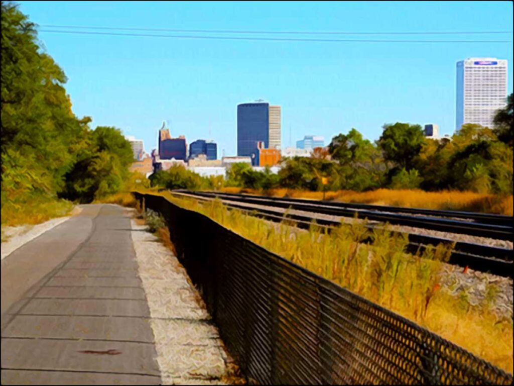
Built on a former roadbed of the Chicago, Milwaukee, St. Paul and Pacific Railway, the Hank Aaron Trail stretched from Lakeshore State Park near Discovery World west to Miller Park by August 2006. In 2010, a four-mile westward extension to 94th Place was completed, setting the total trail length to ten miles.
In November 2011, the trail was expanded from 94th Place to Underwood Parkway. The compacted gravel section of the trail west of 94th Place was paved with the completion of the reconstruction of the Zoo Interchange in 2018. The overall length is approximately 14 miles, including several sections where there are parallel segments.
Today, Milwaukee’s Grand Old Leaf is a well-loved multi-use trail system for cycling, walking, birding and running around county. Of its now existing 135 miles, almost a quarter of the trail runs along Lake Michigan beautiful lakefront. Remarkably, the modern trail closely parallels what its originators (Morgan, Snead and the others) imagined it to become in 1939. The now 30-year-old plan to add a bike lane on the Hoan Bridge in an effort to make Milwaukee more bicycle-friendly perseveres as a vision for Milwaukee’s most avid riders.
Until then, bicycle lovers must settle for the annual UPAF Ride for the Arts fundraiser. The Ride supports local artists and groups who provide world-class performances and arts education to the community. This annual tradition dates back 42-years and incorporates Milwaukee’s iconic Hoan Bridge. Participants travel as few as 5 miles or as many as 60 along the picturesque route reaching as far south as Cudahy. It’s just like riding a bike!
The Lakefront’s Veterans Park
The first organized opposition to a Milwaukee area freeway came in September 1965. A public hearing was held to discuss a six-lane lake freeway through Veterans (then Juneau) Park. The segment becoming known as the “Downtown Loop Closure Freeway” would have stretched between the eastern end of the Park East Freeway and the East-West Freeway just south of downtown. Opponents felt such a concrete monstrosity would hinder access to the lakeside, downtown Milwaukee’s newest prized possession.

After all, the largest part of the lakefront’s land reclamation project, Veterans Park, had only been completed a few years prior. Constructed out of 2.5 million cubic yards of filled-in rock and soil, the outline of this park alone took more than five years to complete. The fill mostly originated from land displaced by the newly built I-43 and I-94 corridors.
The battle over the “Downtown Loop Closure Freeway” waged on until 1971. Opponents to the freeway secured a court injunction against the project. Two years later, this was upheld by the State Supreme Court. As freeway opposition grew around the city, construction stalled.
Today, the popular park features a lagoon, wide open greenspace equipped with picnic areas, a beautiful art museum, a commemorative war memorial and the Lake Line of the Oak Leaf Trail.
The Lakefront’s Art Museum
In the 1870s, a number of organizations were founded and tasked to bring an art gallery to Milwaukee. At the time, the city was a growing port town with little or no facilities to hold major art exhibitions. For almost a decade, all attempts to establish a significant art gallery were unsuccessful. Finally, in 1881, business magnate Alexander Mitchell contributed his complete art collection to help construct Milwaukee’s first permanent gallery.
In 1888, an assembly of German panorama artists and local businessmen founded the Milwaukee Art Association. That same year, British-born businessman Frederick Layton erected, endowed and donated artwork for the now lost Layton Art Gallery. In 1911, the Milwaukee Art Institute was also constructed to hold other exhibitions and collections. It was built adjacent to the Layton Art Gallery.
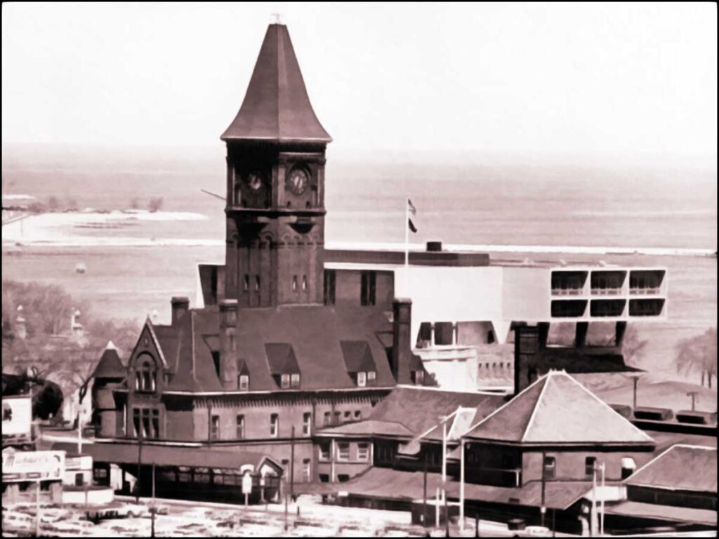
Image courtesy of the Milwaukee Public Library
The Milwaukee Art Center, existing now as the Milwaukee Art Museum, was formed when the Milwaukee Art Institute and Layton Art Gallery merged their collections in 1957. The center moved into the newly built Eero Saarinen-designed Milwaukee County War Memorial built directly behind the now demolished German-styled Lake Front Depot.
Efforts were made to save the Lake Front Train Depot, however it was torn down in 1968 due to lack of funding. The two lower floors of the memorial were allocated for use as an art gallery. Further exhibition space was created in 1975 and its most significant addition was planned for completion in 2001.
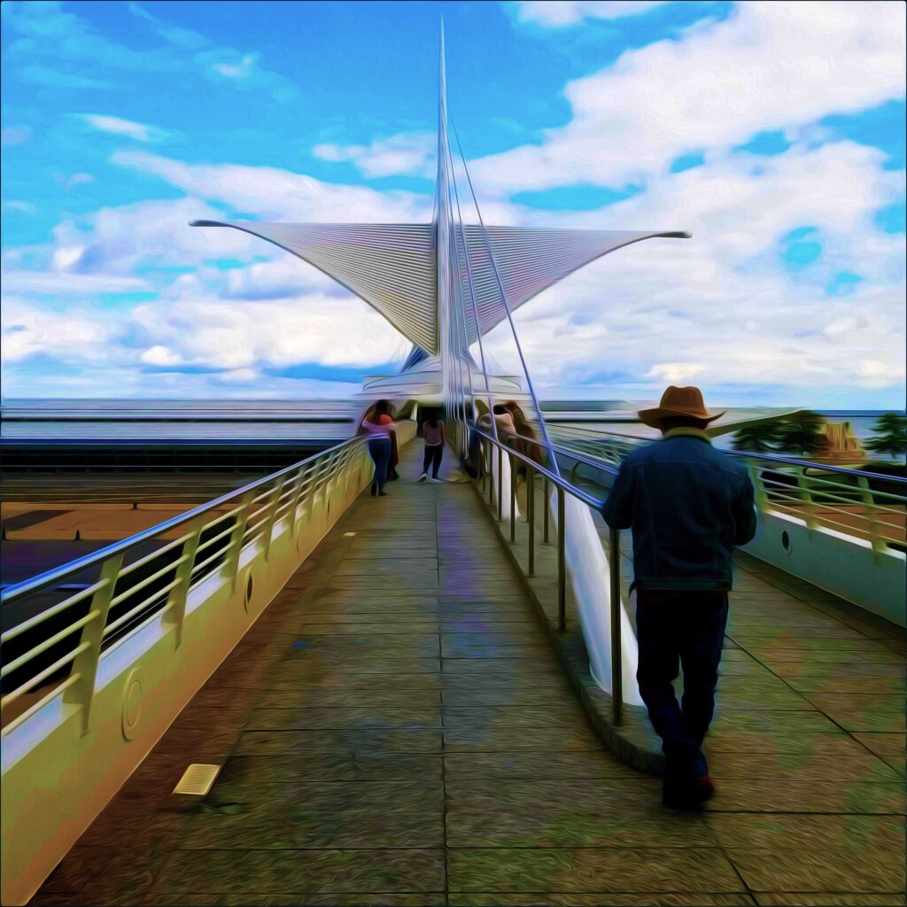
Known for his curved, flowing buildings, Calatrava was hired to design an addition for the Milwaukee Art Museum in 1994. At that time in his career, he had little name recognition in the United States. Known colloquially as, “The Calatrava,” the exquisite Quadracci Pavilion and Reiman Foundation Bridge were completed in 2001.
Designed to represent the shape of a ship looking over Lake Michigan, the gothic styled museum overlooks Lake Michigan and the Lakefront’s Veterans Park. Inspired by Frank Lloyd Wright, he used steel, concrete and computer modeling to create a composition with a feel that is both natural and structurally impossible.
Shaped like a floating cross with wings supported on only one end, the modernist building includes a reception hall, auditorium, exhibition space and a grand reception area capped with a glass roof. It’s footbridge, another cable-stayed, spans Lincoln Memorial Drive. The bridge connects the Milwaukee Art Museum along the lakeshore to the east side of the downtown business district.
The mobile sunscreen of the Milwaukee Art Museum is one of its sustainable features. Sensors covering the fins constantly monitor wind speed and direction. Making it responsive to the weather, the wings are adjusted according to the wind as well as the light and shading requirements. Its green roof is also a source of aesthetic and environmental benefits. Benefits include the extension of roof life, stormwater management and energy conservation.
There’s so much out there just waiting to be learned. Inspiring a natural sense of wonder and curiosity will empower a child’s lifelong love of learning. Winter learning adds a dimension of enrichment that can’t be taught within the walls of the classroom. Not a biker? It’s never too late to turn over a Grand Old Leaf!
Do you have more questions about A Grand Old Leaf or Winter Learning? Do you have a suggestion for another blog topic? Please send me an email with your ideas or experiences at grumble.services@gmail.com.
If you find this article helpful, please share it. Please join us, if you have yet to do so. Subscribe below and receive articles like this one in your email box weekly. Thank you!
Read More: Milwaukee’s Emerald Necklace
All Rights Reserved • © 2023 Grumble Services LLC • grumbleservices.com

References and Read More:
Muench Albano, Laurie (2007). Milwaukee County Parks (WI) (Images of America). Arcadia Publishing, Charleston SC.
OnMilwaukee Staff Writers, “Cyclists may get a bike path with a view.” On Milwaukee, November 13, 2001. onmilwaukee.com/articles/hoanbike. Accessed January 10, 2023.
OnMilwaukee Staff Writers, “Milwaukee’s Freeway History.” OnMilwaukee. January 7, 2011. onmilwaukee.com/articles/milwaukeefreewayhistory. Accessed November 11, 2022.
Rothenbueler Maher, Jill (2019). Milwaukee County’s Oak Leaf Trail: A History. The History Press, Charleston SC.